Imagine in alta resoluzione(3 600 × 2 800 pixel, dimensione del file: 1,16 MB, tipo MIME: image/jpeg)

Questo file proviene da Wikimedia Commons e può essere utilizzato da altri progetti. Di seguito viene mostrata la descrizione presente nella pagina di descrizione del file.

sommariu

Descrizzione
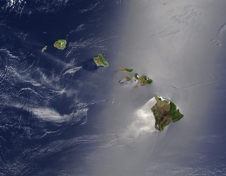
English: Satellite view of Hawaii archipellago (USA).

Original description from NASA:

"A silver swath of sunglint surrounds half of the Hawaiian islands in this true-color Terra MODIS image acquired on May 27, 2003. Sunglint reveals turbulence in the surface waters of the Pacific Ocean. If the surface of the water was as smooth as a perfect mirror, we would see the circle of the Sun as a perfect reflection. But because the surface of the water is ruffled with waves, each wave acts like a mirror and the Sun’s reflection gets softened into a broader silver swath, called the sunglint region.

"In this scene, the winds ruffling the water surface around the Hawaiian Islands create varying patterns, leaving some areas calmer than others. Southwest of Hawaii and Maui, on their leeward sides, calmer waters are indicated by brighter silver coloration. Conversely, notice how most of the vegetation on the Hawaiian Islands grows on their northeastern, or windward, sides.

"From lower right to upper left, the “Big Island” (Hawaii), Maui, Kahoolawe, Lanai, Molokai, Oahu, Kauai, and Niihau islands all make up the state of Hawaii, which lies more than 2,000 miles from any other part of the United States. The small red dot on the Big Island’s southeastern side marks a hot spot on Kilauea Volcano’s southern flank. Kilauea has been erupting almost continuously since January 1983, and is one of the world’s best studied volcanoes."
Français : Vue satellite de l'archipel d'Hawaï (États-Unis).
Data
Fonte NASA. Image courtesy Jacques Descloitres, MODIS Land Rapid Response Team at NASA GSFC. (IotD Date: 2003-06-03. IotD ID: 15304)
Autore Jacques Descloitres
Altre versioni
Modified version
Questa è una immagine ritoccata, il che significa che è stata modificata digitalmente dalla sua versione originale. Modifiche: cloned out and healed little red line on the big island. La versione originale può essere vista qui: Hawaje.jpg. Le modifiche sono di IdLoveOne.

Derivative works

Opere derivate da questo file:  Hawaje-NoRedLine.jpg

Licenzia:

Public domain Questo file è nel pubblico dominio perché creato dalla NASA. La politica sul copyright della NASA afferma che «il materiale della NASA non è protetto da copyright a meno che non sia specificato altrimenti». (NASA copyright policy e JPL Image Use Policy).
Attenzione:

Didascalie

Aggiungi una brevissima spiegazione di ciò che questo file rappresenta

Elementi ritratti in questo file

raffigura talianu

27 mag 2003

Cronolugia di l'imagine

Fare clic su un gruppo data/ora per vedere il file come si presentava nel momento indicato.

Data/ÓraPrevisualizzazioneDimensioneCuntributoreCummentu
attuale18:19, 26 utt 2005Previsualizzazione di a versione di3 600 × 2 800 (1,16 MB)PalladinusHawaii Islands

La seguente pagina usa questo file:

Usu glubale di u schedariu

Anche i seguenti wiki usano questo file:

Metadati